Coach Transfer from Kings Canyon Resort to Ayers Rock (Uluru)
6 hours
From AUD $205
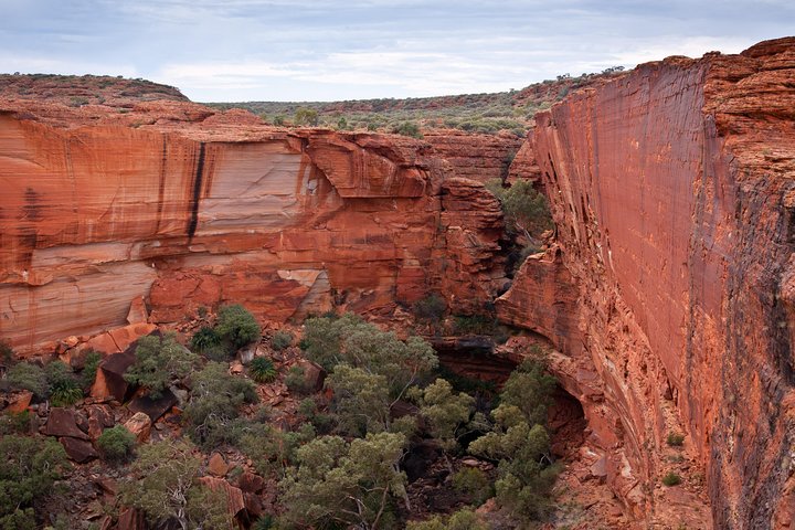
Kings Canyon's famous Rim Walk cuts along 100-metre sandstone cliffs above the Garden of Eden waterhole and the beehive domes of the Lost City, deep in Watarrka National Park.
Kings Canyon cuts a 100–metre gash through the George Gill Range in the middle of the Northern Territory's Red Centre, and the first sight of it from the rim — sheer red walls dropping to a green thread of waterholes, sandstone domes stacked up like a fossilised city — is the kind of thing that makes people go quiet. It sits inside Watarrka National Park, roughly midway between Alice Springs and Uluru, and for a lot of Red Centre road–trippers it ends up being the unexpected highlight of the whole trip — the place they didn't plan much time for and then didn't want to leave.
The reason people come is the Rim Walk, a six–kilometre loop along the canyon's edge routinely ranked among the best day walks in Australia. But Watarrka is more than one walk: a permanent waterhole locals call the Garden of Eden, a field of beehive–shaped sandstone domes known as the Lost City, gentler trails for anyone who can't do the full rim circuit, and a genuinely serious heat problem the Parks and Wildlife Commission manages with a hard 9am cut–off on the worst days. None of that is incidental to the visit — it is the visit.
Our writer Hamish drove in from Alice Springs on the sealed route in late June, on the road before six to make the rim by first light. He'd read the warnings about the climb and still underestimated it — "Heart Attack Hill," the initial staircase up onto the rim, does exactly what the nickname promises. What stayed with him wasn't the climb, though. It was standing at the first lookout twenty minutes later, watching the sun come up along a canyon wall that has been sitting there, more or less unchanged, since long before there were mammals to watch it.
Watarrka takes its name from the umbrella bush that grows through the George Gill Range, and the Luritja people have lived on this country for tens of thousands of years, moving between the range's permanent rockholes and waterholes long before explorer Ernest Giles rode through in 1872 and named the canyon after Fielder King, an old friend back home who had nothing to do with Central Australia at all. Pastoral settlement from 1889 hit the Luritja hard, pushing people into the range's more defensible pockets and disrupting a system of land management and lore that had run uninterrupted for millennia. Watarrka National Park was proclaimed in 1989; in 2012 land ownership formally returned to Aboriginal traditional owners under freehold title, with the park now managed jointly by the Luritja Aboriginal Land Trust and the Northern Territory Parks and Wildlife Commission.
That joint management shows up in small, deliberate ways — signage that explains the cultural significance of particular waterholes rather than just their scenery, sections of the park that are closed to protect sacred sites, and a Board of Management with Luritja representation shaping how new visitor infrastructure gets built. It is worth reading the interpretive signs properly rather than walking past them; Watarrka's story is Luritja first and scenery second, even if most visitors experience it the other way around.
The Rim Walk is the reason Kings Canyon is on every Red Centre itinerary, and it earns the reputation. It is a six–kilometre loop, allow three to four hours, and it starts with the climb everyone warns you about — several hundred uneven sandstone steps straight up the canyon's southern wall, gaining most of the walk's 100 metres of elevation in the first fifteen minutes. After that it flattens into a genuinely spectacular circuit around the rim, weaving between beehive domes of eroded sandstone that visitors have nicknamed the Lost City, before dropping via a steep side staircase into a narrow, shaded gully holding the Garden of Eden — a permanent waterhole fringed with cycads and ferns that feels like a different climate zone entirely. From there the track climbs back out and traces the canyon's northern rim before descending to the car park.
There's a genuinely fun bit of trivia attached to all this: the climbing scene in The Adventures of Priscilla, Queen of the Desert — three drag queens in full sequins, teetering across the rock in heels — was filmed up here on the Kings Canyon rim, not on Uluru, which was the original script's location before the producers (rightly) decided that clambering over a sacred Aboriginal site in a frock was not on. Watch the film again before you go; you'll recognise the domes.
Go anticlockwise if you have a choice — most walkers do the steep climb first while they're fresh and descend into the Garden of Eden partway round, rather than saving the hardest section for last. Carry more water than you think you need; there is none on the track once you leave the car park.
Not everyone wants, or is able to do, several hundred steps and six kilometres of exposed sandstone, and Watarrka doesn't force the issue. The Kings Creek Walk is a two–kilometre return stroll along the canyon floor, tracking beneath the same towering walls the Rim Walk looks down from, without any climbing at all; the first 700 metres are wheelchair accessible with assistance, and it is a genuinely satisfying way to feel the scale of the place if the rim isn't an option. Further along Luritja Road, the Kathleen Springs Walk is a flat, fully wheelchair–accessible 2.5–kilometre return path to a permanent, spring–fed waterhole tucked into a side gorge — a site of deep significance to the Luritja, with interpretive signage covering both Aboriginal history and the area's pastoral past. Swimming isn't permitted at either waterhole; they are cultural sites and refuges for wildlife, not swimming holes.
Either of these is a good call for anyone travelling with young kids, older relatives, a dodgy knee, or simply for a cooler part of the day when the rim is closed. Neither feels like a consolation prize.
The rock underfoot is old even by Central Australian standards. The canyon is cut into layers of Mereenie Sandstone, laid down as river sand and gravel somewhere between 400 and 440 million years ago, when this part of the continent sat closer to the equator and life on land barely existed. Around 300 million years ago, the Alice Springs Orogeny — a prolonged spell of continental collision and mountain–building — buckled those flat sedimentary layers upward into the George Gill Range. Everything since has been erosion: wind, flash flooding and frost stripping the softer layers away, leaving the harder, quartz–cemented sandstone standing as sheer walls and, on the plateau above, as the beehive domes of the Lost City, shaped by water finding the joints in the rock and slowly widening them. It is why the canyon feels less like a single feature and more like an exposed cross–section of deep time — because that is exactly what it is.
This is the part of the guide we'd rather not have to write, but it matters more than anything else here. Watarrka sits in one of the hottest parts of a very hot continent, and the Rim Walk offers almost no shade across its full loop. Every summer, rangers deal with walkers suffering serious heat exhaustion on the climb, some requiring stretcher evacuation off the rock; over the years, the toll from underestimating this walk in extreme heat has, at its worst, included fatalities. That history is exactly why the Northern Territory Parks and Wildlife Commission enforces a genuinely hard rule: on any day the forecast reaches 36°C or above, walkers must start the Rim Walk before 9am, and the track is closed to new starters after that time, full stop. Check the day's forecast through the Bureau of Meteorology before you commit to a start time, not after.
Even below that threshold, treat the rim seriously in the warmer months. Carry at least two litres of water per person, wear a hat and real walking shoes rather than sandals, start early regardless of the forecast, and tell someone your plan if you're travelling solo. The NT Parks and Wildlife website carries current alerts and closures and is worth checking the morning of your walk, not the week before.
Kings Canyon Resort, a short drive from the canyon car park, is the accommodation base for almost everyone visiting Watarrka, and there is genuinely nothing else out here to compete with it. It spans a range of room styles from powered camping and budget cabins through to hotel–grade rooms, with a pool, a servo, a small general store and a couple of places to eat — enough to make a one or two–night stay comfortable without pretending to be a destination resort in its own right. Book ahead in the cooler months; this is the only real bed for a long way in any direction and it fills up around the peak walking season.
Kings Creek Station, back towards Alice Springs, offers a smaller working–station alternative with camping and safari–tent options, plus quad bike and helicopter tours over the canyon if you want to see the George Gill Range from above before you walk it.
Most visitors reach Kings Canyon on a loop between Alice Springs and Uluru, and the fully sealed route is the easiest option in any vehicle. From Alice Springs, that's the Stuart Highway south, the Lasseter Highway west, then Luritja Road north — around 470 kilometres and a solid four to five–hour drive, longer if you stop at the lookouts along the way. From Uluru, it's roughly 300 kilometres back out along the same Lasseter Highway and Luritja Road, about four and a half hours. Fill the tank before you leave either end; fuel stops in between are sparse and worth treating as mandatory rather than optional.
It is a long way from anywhere else in the Territory — even Darwin is the best part of two days' drive away — which is exactly why most people build Kings Canyon into a dedicated Red Centre loop rather than a side trip.
If the sealed highway feels like the long way round, it kind of is. The Mereenie Loop – part of the broader Red Centre Way that also takes in the western MacDonnell Ranges — cuts the Alice Springs to Kings Canyon run down to around 330 kilometres via Namatjira Drive and an unsealed, often corrugated stretch of road through Aboriginal land. It's a genuinely good drive in a high–clearance vehicle, threading past Glen Helen, Gosse Bluff and a string of gorges that most sealed–road travellers never see, but it demands a permit — sold cheaply at the Alice Springs Visitor Information Centre, Kings Canyon Resort, Glen Helen Lodge and Hermannsburg — and it comes with a firm no–camping rule along the route itself. Corrugations can be brutal after dry spells; drop your tyre pressure, carry a spare and don't attempt it in a low–clearance rental without checking the fine print on your hire agreement first.
We'd only send confident 4WD drivers with a genuine spare and some slow–road patience down the Mereenie Loop. Everyone else should take the sealed route and not feel like they're missing out; arriving tired from corrugations is a bad way to start a 6–kilometre rim walk the next morning.
May through September — the dry season — is when Kings Canyon actually works as a walking destination. Days sit in the low–to–mid twenties, mornings are cold enough for a jacket at the lookout, and the Rim Walk is comfortably walkable at almost any hour. June and July are peak season for exactly this reason, so book accommodation ahead. October through April brings the real heat — regularly 38–42°C by midday — and the 9am rule bites often; plan an early alarm or accept you might be limited to Kings Creek and Kathleen Springs instead. Tourism NT publishes seasonal guidance worth reading before you lock in dates, particularly if you're travelling in the shoulder months of April or October when conditions swing either way.
Kings Canyon has a habit of outperforming expectations. People arrive expecting a quick add–on to an Uluru trip and leave saying the rim walk was the best few hours of their whole Red Centre loop — and having watched the sun clear the canyon wall at Heart Attack Hill's lookout more than once now, we understand why. Hamish's version of that moment came halfway round the rim, past the Lost City domes, when a wedge–tailed eagle rode a thermal up out of the gorge at eye level and hung there for what felt like a full minute before drifting off toward the Garden of Eden. Nobody on the track said a word. That's Watarrka — ancient, unglamorous about its own dangers, and completely unforgettable if you respect the heat, carry enough water and get up early enough to meet it on its own terms.
Live forecast from Open-Meteo. Updated each time the page loads.
Based on 30 years of weather data. Sweet spot: May, Jul, Aug — mild temperatures, low rainfall and plenty of sun. Avoid Jan, Feb if you can — typically the wettest or hottest stretch of the year.
Points of interest within 25 km, pulled from OpenStreetMap. Distances are straight-line; check road access before heading out.
Real road distance and driving time to other destinations in the state. Click through for fuel estimates, suggested overnight stops, and tours along the way.
Browse every guide, listing and how-to for Kings Canyon.